I first came to know the existence of the demolished
Anson Road Stadium after I read a line from the veteran journalist Godfrey Robert's book "The Malaysia Cup" published back in 1990.
USED TO THINK JBS WAS THE OLDEST
Before that, it was always in my opinion that
Jalan Besar Stadium was the oldest football stadium in Singapore (even though the old arena used to function as a rugby and hockey venue as well) due to its aged facade, which I noticed when I first visited the ground back in the early 1990s, before the redevelopment program began in December 1999.
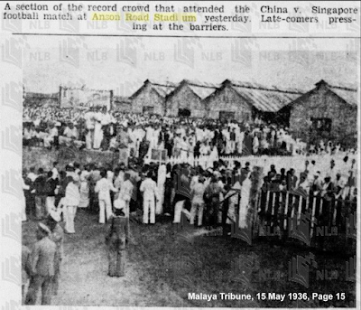 |
Big turnouts like this were common at Anson Road Stadium (credit: NLB archive)
|
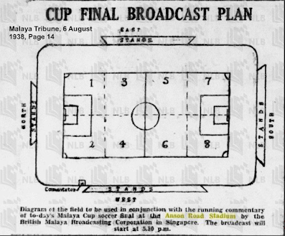 |
| Field diagram for listeners tuned in for radio commentary in the old days (credit: NLB archive). |
Recently, when I chanced upon an online article that provides a scribe on the arena, it piqued my interest to find out where exactly this stadium was located in the Tanjong Pagar district.
EXHIBITION VENUE TURNED INTO STADIUM
According to this "Singapore Infopedia" article of the National Library Board (NLB) site, the plot where the stadium was located was meant to serve as the venue for the 1922 "Malaya-Borneo Exhibition", a regional tradeshow to showcase the economic achievements of British Malaya and Borneo.
Following the exhibition, a loan of $25,000 was approved by the Legislative Council to convert the venue into a sports stadium which was completed and officially opened on 19 July 1924 featuring a "Singapore Cup" match between HMS Iroquois and HMS Pegasus.
TRACKING DOWN THE SITE
Armed with details given by the above-mentioned online article and old street map sourced from its sister site at "Spatial Discovery", I headed down to Tanjong Pagar to map out where the Anson Road Stadium used to be.
Based on the old map, it is clear that not far from where the stadium was located was the Telok Ayer Basin, which in the early days served as a dock for merchant ships to unload their goods.
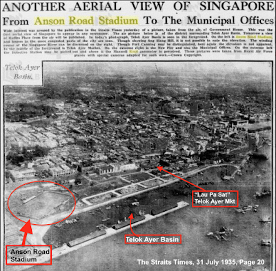 |
| A rare bird's-eye view of Telok Ayer Basin (credit: NLB archive) |
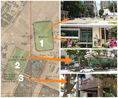 |
| Locations as shown based on information (credit: map from "National Archives of Singapore") |
The Past And The Present of "Telok Ayer Basin" and its surrounding areas
- Site (1) is the site where Anson Road Stadium was and it is now the cross junction near the Singapore Conference Hall (SCH).
- The site (2) was where YMCA Sports Ground once occupied is now part of the AXA Tower.
- Across (2) is the plot (3) where it used to be Nanyang Chinese Student Sports Field (presently the MAS Building).
I traced the map using Prince Edward Road and Anson Rd/Robinson Rd as the "anchor points".
Diagonally across it was the YMCA Sports Ground with Nanyang Chinese Students' Sports Field next to it, and because of its location near the port, it wasn't uncommon to see facilities like godowns, quarantine centres within the vicinity.
Years of redevelopment that took place in the area had largely altered the look of Tanjong Pagar.
Information from the "Singapore Infopedia", however, did mention that the site where the Singapore Conference Hall (SCH) is now is next to where the stadium was; as such, this could possibly be the closest indication of the demolished stadium.
CLUES FROM THE OLD MAPS
Probably, it is.
Along the way, I came across a few maps and an old photograph of the vicinity that more or less confirmed that the present site of SCH was once the location of Anson Road Stadium.
A 1944 map from the National Archives of Singapore (NAS) indicated that the ground stood beside one end of the Telok Ayer Basin. In contrast, a 1954 map showed its disappearance (as circled).
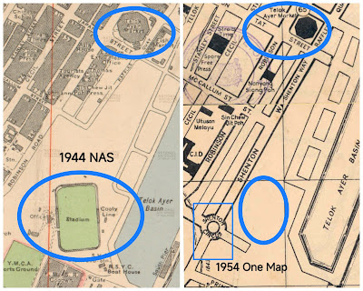 |
| The maps of Telok Ayer (1944 and 1954, as credited) |
Further information revealed that after the Second World War, Anson Road Stadium was taken over by the British military and later used as a dumping ground.
Subsequent redevelopment led to the opening of Shenton Way in July 1951, which effectively sealed the fate of the arena and ended any hope of a new one at the site.
Using the Telok Ayer Market (also known as Lau Pat Sat) and the Telok Ayer Basin as anchors, two more maps published in 1972 and 2009 show the SCH marked on them.
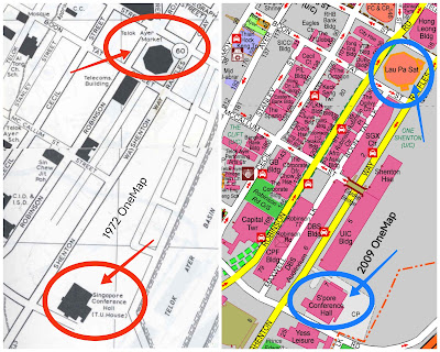 |
| The maps of Telok Ayer (1972 and 2009, as credited) |
Sadly, there is nothing visible, such as a commemorative marker or signage, to indicate the site of Anson Road Stadium.
Perhaps it is time for the relevant authorities to erect a commemorative plaque at the premises of SCH to honour the legacy of this first football ground on the island - etched in local folklore as the
“Wembley of Malaya.”(P.S 1: Some images in this entry were reproduced from sources like NLB online newspapers archives, as credited, should anyone feel it's inappropriate to have any of the media shown, please kindly email me as soon as possible and I will remove them upon request.)
(P.S 2: I stand to be corrected should there be any mistake in this entry, please feel free to email me if there is, thanks)
PS: This article was first published on 16th August 2019 and is being refurbished with additional details in line with the content repurposing of this blog.